Skip to main content Skip to footer
Menu
Water running in the river Water running in the river

Setting water quantity limits

Resource consents allow for groundwater or surface water to be allocated amongst different users.

Water take consents can be sought for any purpose (unless it is a prohibited activity) but will only be granted where the proposed take is efficient and appropriately manages adverse environmental and cultural effects.

Council is required by law to accept and process a complete consent application for any kind of water use. Each consent application is assessed and considered on a case-by-case, and first in-first served basis.

We currently manage more than 1,200 active resource consents to take and use water in the Bay of Plenty. These include for drinking water, electricity generation or industrial use, horticulture, and agriculture. Numerous consents are held for municipal water supply and some are held by water bottling companies. 

Irrigation NZ have issued some advice for irrigators to help them manage their water use during dry conditions

Surface water limit setting

This section includes some technical terms.  If you are unfamiliar with these, they are explained in the glossary at the end.

Current surface water rules

Most applications to take more water than the permitted limits are assessed case by case, as a discretionary activity under the Regional Natural Resource Plan (Rule 43).
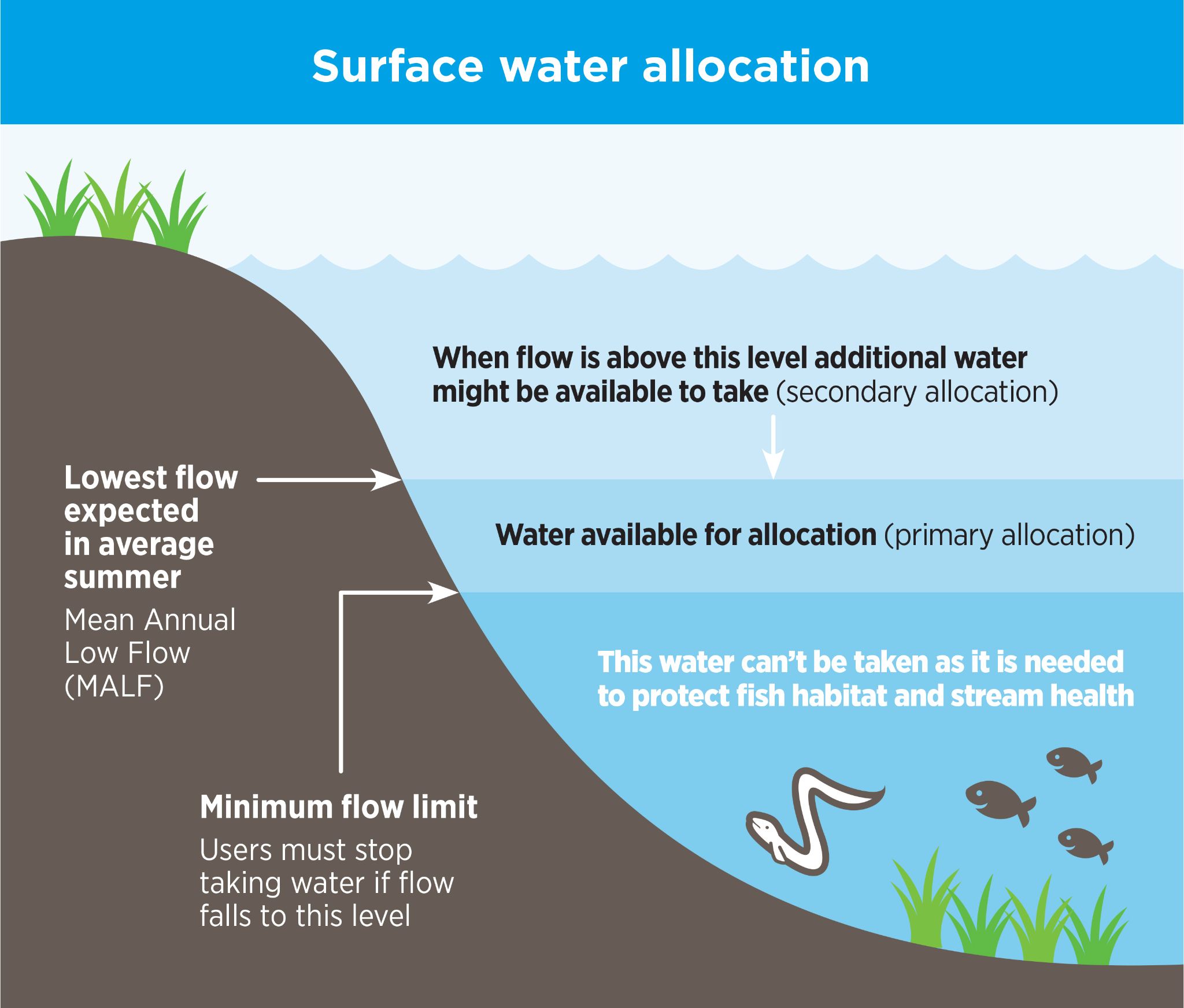
Under the current rules, a conservative default water allocation limit is used to determine how much water is available to be taken from a stream or river (Table 13, Policy 66). The rules also allow council to consider an alternative allocation limit, where the applicant provides supporting scientific information (Policy 68).

Since the Regional Plan was developed more than 20 years ago, council has gathered more information. This information can be used to help inform decision-making on resource consent applications.

There are two main parts to determining whether water is available to take from a stream or river:

  1. estimating how much water is flowing in the stream or river, and
  2. determining how much of that water can be taken while maintaining ecosystem health.

Estimating flow in streams and rivers

We operate 33 continuous stream-gauging sites across the region that measure and report stream flows. Over time, this data (along with additional flow measurements collected on an occasional basis from other streams) builds a picture of the range and pattern of stream flows, allowing us to identify typical low-flows.

Low-flow measures used

The Regional Plan refers to flow based on the Q5 7-day low flow.

Our proposed future approach follows the lead of key national science agencies and other councils by using a different low flow measure: Mean Annual Low Flow (or MALF).

  • MALF represents the lowest flow expected in an average dry year.
  • The flow at MALF is higher than Q5 7-day low flow, because Q5 7-day low flow represents the lowest flow expected in a 5 year period rather than average year that is MALF.

As with flood estimates (such as a 1-in-100-year flood), flows lower than MALF or Q5 7-day low flow can occur more or less frequently than expected.

We are developing a minimum flow management map that groups together streams with similar flow characteristics. This will allow us to manage the taking of water to avoid causing a breach of the minimum flow across all streams in our region based on a continuous gauging site within each group.

Maintaining ecosystem health

The default water allocation limit in the Regional Plan provides 10% of the Q5 7-day low flow to be available for allocation. This is generally considered a conservative limit and is useful where limited site-specific information is available.

Fish are often the most sensitive component of stream ecosystems, so we intend on basing future water allocation limits on maintaining healthy fish populations.
Different fish species have different habitat needs, and each stream has unique characteristics such as shape, rate of flow and depth.

Our scientists have surveyed 53 streams across the region using an international accepted modelling approach to assess how water takes affect fish populations. Using these studies, along with other information, we have developed updated assessments of how much water needs to remain in streams to retain fish habitats. These assessments better reflect individual stream characteristics and prioritise protecting fish habitat.

This information has been published and is available in our Recommended steps to set minimum flows for ecological values in Bay of Plenty waterways report and can be used to support consent applications. An indicative surface water accounting tool is also being developed that will be available online and will show:

  • total water available for allocation
  • how much is already allocated
  • how much remains available under either:
    • the default 10% Q5 7-day low flow method, or
    • the newer MALF-based assessment to provide regionally consistent habitat retention for fish.

Under both approaches, allocation limits are based on the difference between:

  • the minimum flow (the flow that must remain in the stream), and
  • either Q5 7-day low flow or MALF 7-day low flow.

What this means for resource consent applications

The Regional Plan default water allocation limit is the difference between Q5 7-day low flow and the minimum flow.

The Recommended Steps report provides additional information about minimum flows needed to support the retention of fish habitat. The Regional Plan enables this information to be used to inform individual consent applications.

Water reliability

Reliability describes how often water users can take their allocated water without restrictions.

To protect rivers and streams, we may require water takes to stop when flows approach the minimum flow. This helps prevent the taking of water causing flows to drop below levels needed to support ecosystem health.

By setting allocation limits based on the difference between Q5 7-day low flow or MALF and the minimum flow, we generally expect water takes to be available most of the time. However, during very dry periods especially when allocation is close to the limit, restrictions may occur in the future.

Information about how water restrictions are currently managed is available on our Dry weather water management page. As outlined above, we are also developing a minimum flow management map to support the identification of streams with similar flow patterns and manage water takes when necessary.

Minimum flow: The flow at which water users should stop taking water to protect fish habitat. At times, natural conditions may cause flows to drop below this level.
Allocation limit: The amount of water available for allocation.
Reliability

How often water users can take all or some of their allocation because the flow is above the minimum flow.

MALF: Mean Annual Low Flow – the lowest flow (over a seven-day period) expected in a typical year.
Q57-day low flow The mean 7-day low flow that has a 20% (or one in five) probability of occurring in any one year.  ‘Q’ is simply a standard statistical symbol used in hydrology to represent flow. ‘5’ refers to 1 in 5 year (or 20% probability)


Surface water allocation illustration

Groundwater limit setting

Current groundwater rules

The Regional Plan does not set numeric limits for taking groundwater. Instead, it requires groundwater to be managed using a sustainable yield approach, ensuring water levels are not permanently or unsustainably lowered and that water quality is not degraded (Policies 70 and 73).

Estimating groundwater availability

Setting groundwater limits involves balancing several factors, including:
•    making water available for users
•    managing effects on connected streams, rivers and wetlands
•    avoiding saltwater intrusion
•    using the best available scientific information.
There is no single “correct” number. Limits reflect both science and values-based decisions about risk and sustainability.

Groundwater allocation studies

In 2016, for the first time, Regional Council tried to set numerical groundwater allocation limits based on the best available groundwater studies at the time. Although these limits were not incorporated into a statutory plan, they have been used operationally until very recently.

We now have more detailed and comprehensive information than what was available in 2016, which has changed our understanding of how much groundwater is available for allocation. The new information is based on the finding in the Groundwater Allocation Limits for the Bay of Plenty Region report and covers the entire region, addressing gaps in the earlier work. As this information has not yet been publicly notified, it must be applied with appropriate caution.

Our indicative groundwater accounting tool is being updated to show the new methodology. In the interim, for updated indicative sustainable groundwater allocation information, please contact our Duty Consents Planner on 0800 884 881. 

While the newer work is generally considered more robust, there may be situations where a more conservative interpretation is appropriate.

Key differences in the updated methodology include:
•    Groundwater allocation limits defined across the whole region
•    Smaller groundwater management units
•    Reduced water availability in some northern Tauranga Moana areas; and
•    Increased water availability in the Kaituna, Pongakawa and Waihī Estuary areas.

Graphic of groundwater flow cycle

Warm groundwater in the western Bay of Plenty

A large low temperature geothermal system is located between Waihī Beach and Maketu (see map). This system is used for both heating and irrigation purposes.

For water allocation purposes, warm groundwater is accounted for within the groundwater management unit in which it occurs. However, additional considerations are required to ensure the geothermal heat values are managed sustainably. Further information on the Tauranga Geothermal System, known as Tauranga, Group 5.


Taking groundwater warmer than 30oC (or geothermal water) has specific rules due to the unique nature of this resource. A resource consent is required for most geothermal water takes.

Map of Warm groundwater in the western Bay of Plenty