
Pāpāmoa Hills Cultural Heritage Regional Park
Pāpāmoa Hills carpark connection
Users of Pāpāmoa Hills Cultural Heritage Regional Park will soon be able to move safely between the two carparks, with construction of a new connection track beginning on Monday 15 June.
The works will create a new trail through adjoining land and establish a pathway along the roadside. Once complete, this will provide a safe route between the carparks.
During construction, please follow all traffic management directions to help keep yourself and others safe.
Construction is expected to take up to two months, weather permitting. Access to the park and both carparks will remain open during this time.
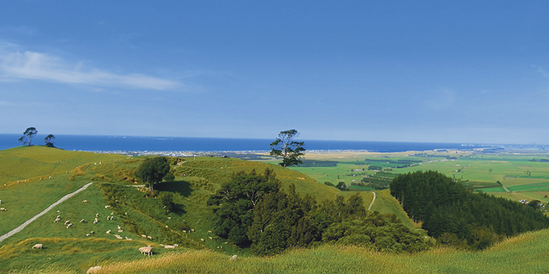
Located in the Western Bay of Plenty, near Te Puke, Pāpāmoa Hills Cultural Heritage Regional Park is a 182-hectare property explored and enjoyed by thousands of visitors each month.
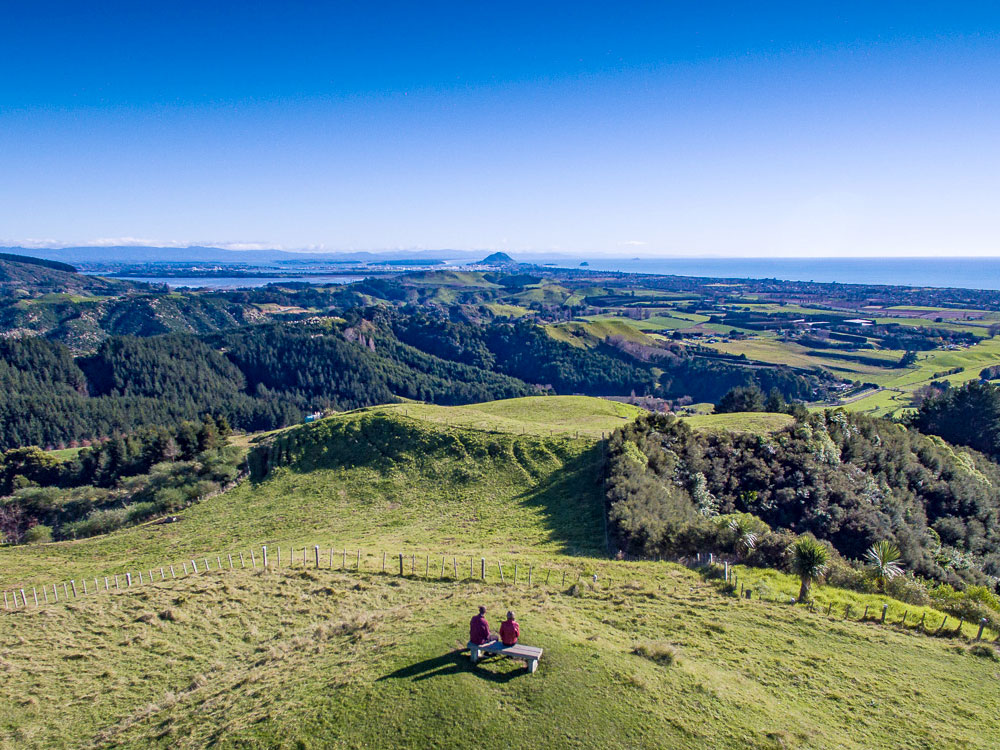
The summit is 224 metres above sea level and offers sweeping views of the Bay of Plenty coastline. There are several tracks through the park which can be used to enjoy the views and explore the numerous archaeological features and many ancient pā sites.

Partnerships
Bay of Plenty Regional Council works in partnership with mana whenua to support the vision of the park. Te Uepu is the shared decision-making entity for the Pāpāmoa Hills Cultural Heritage Regional Park and is made up of representatives from Regional Council, Waitaha, Ngā Pōtiki, Ngāti Pūkenga and Ngāti Hē.
Historical and cultural significance
The Pāpāmoa Hills are among the most significant historical and archaeological landscapes in Aotearoa New Zealand situated in an area with a density of features and number of iwi who date back to the arrival of the Arawa canoe around 1350.
The park is a culturally rich area, with visible evidence of historical Māori occupation and links to Maketū, (Mauao) Mount Maunganui, Tauranga Moana and further afield. Māori from many iwi have long understood the strategic importance of the Pāpāmoa Hills with their commanding position over the surrounding coastline.
There are 1,630 individual archaeological features recorded within the park. Predominantly the features are terraces/tuku and platforms/papatahi, pits, middens and defensive earthworks such as ditches/maioro. The number of archaeological features present in such a small area is very unusual for New Zealand and reflects why it is necessary to protect these sites, and also tell the story of this important cultural landscape.
|
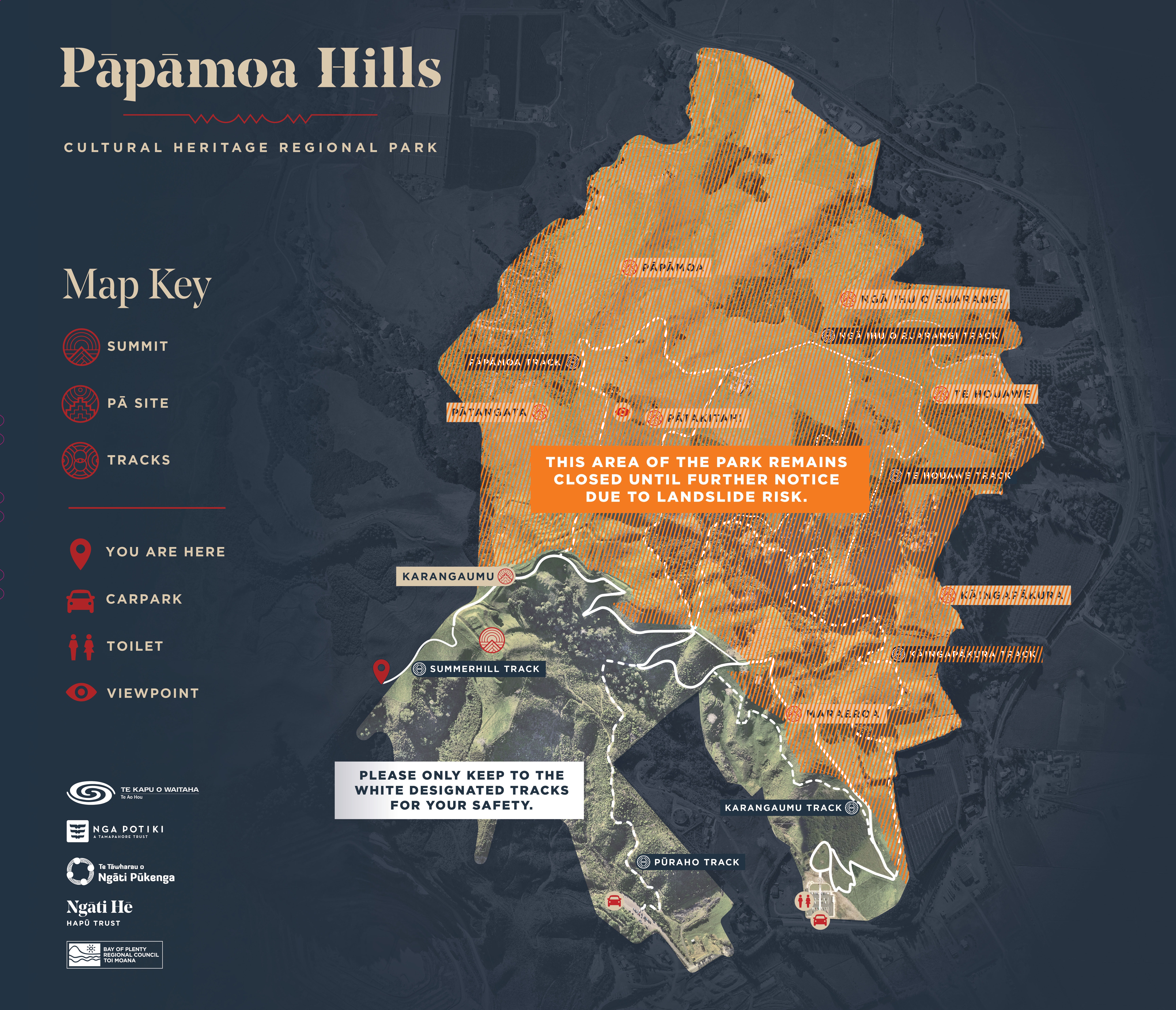
From Friday 3 April, parts of Pāpāmoa Hills Cultural Heritage Regional Park have re-opened, following a full-park closure in January due to weather related damage. The map below indicates which areas are open and closed. Due to its steep terrain, Pāpāmoa Hills Cultural Heritage Regional Park can experience slips and landslides from time to time – particularly after heavy rain. For your safety, please stick to the trails, avoid cliff edges and keep out of any closed areas. |
Getting there
From Tauranga
20 kilometres - 20 minutes
Travel east on State Highway 2 towards Pāpāmoa. Take the Domain Road exit from State Highway 2.
Continue on Pacific Coast Highway/Te Puke Highway to Poplar Lane. Turn right into Poplar Lane.
From Rotorua
65 kilometres - 45 minutes
Take State Highway 33 from to Pacific Coast Highway/Te Puke Highway in Paengaroa.
Follow Pacific Coast Highway to Poplar Lane in Pāpāmoa. Turn left from State Highway 2 into Poplar Lane.
From Whakatāne
80 kilometres - 60 minutes
Follow State Highway 2 to Pacific Coast Highway/State Highway 30 near Paengaroa.
Follow Pacific Coast Highway to Poplar Lane in Pāpāmoa. Turn left from State Highway 2 into Poplar Lane.
Walking tracks
Walking trails are Pāpāmoa Hills Cultural Heritage Regional Park's main feature. Take a stroll through the farmland and enjoy the panoramic coastal views.
The main and most well-known walking track is from the original carpark, located at the end of Poplar Lane, and takes users up to the trig station (at 224 metres). This track leads through pine forest, native bush and open grassland, showcases the terracing on several pā sites and promises breath-taking views from the top. It takes about 45 minutes and rises relatively steeply.
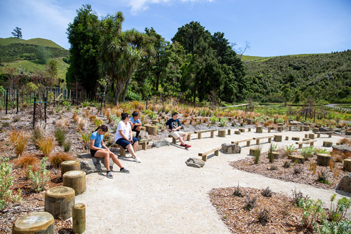
The new visitor experience at the new carpark shares more about the cultural and historic context of the landscape and includes interpretation panels and a 3D map of the park. Track signage and panels can be found throughout the park to help visitors navigate the tracks and understand the significance if the area.
There are several tracks which allow you to explore the cultural heritage of the park and make the most of the expansive views, with most tracks leading you to the many pā sites within the park boundary.

Park rules
Due to the high number of archaeological and cultural sites located within the Pāpāmoa Hills Cultural Heritage Regional Park activities have been restricted to passive recreation.
- No dogs permitted at all times.
- No camping.
- No motorbikes.
- No mountain biking.
- No horse trekking.
- No fires.
- Rubbish free park - care for our environment and take your rubbish home with you.
Things to note
- Park opening hours are from sunrise to sunset and change throughout the year.
- Please note that park gates are locked overnight.
- Remember sunscreen and a hat for sunny days and although most tracks are well formed, good walking shoes are recommended, as is a reasonable level of fitness.
- Take a bottle of water with you as there is no drinking water supply in the park.
- Wayfinding signage can be found throughout the park.
- A 3D park map and information panels are located at the new visitor experience.
- The park is also an operational farm. Please be careful around livestock and give them space. Remember to always leave gates the way you found them.
- Because this park sits on steep, natural terrain, slips and landslides can occur from time to time, particularly after significant rainfall. Please stick to marked tracks, avoid cliff edges, and follow any temporary closures put in place for your safety.
- There are two carparks at Pāpāmoa Hills Cultural Heritage Regional Park, both of which provide access to open trails and a route to the summit. Do not park along Poplar Lane roadside.

2023 upgrade project
In 2017, Regional Council staff and iwi representatives started working together to develop a concept for the new carpark and visitor gateway.
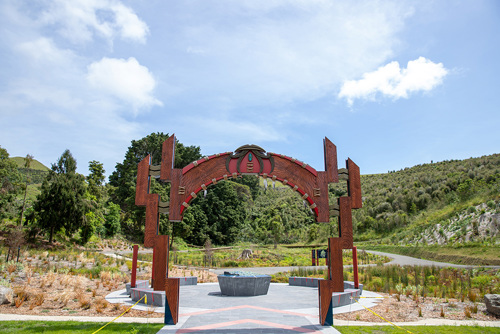
This included the creation of an improved entry from Poplar Lane, increased carparking capacity and improved safety for vehicle access. The new entrance way to the park includes an interpretation area to help park users understand some of the cultural and historic context of the land they are visiting, and improved track signage will enhance the experience for visitors coming to enjoy the park.
The new carpark is approximately 400m north of the old one, providing easy access to some lesser used tracks. The old carpark can still be used; however, the new carpark and visitor entry space are the primary access areas and provide over 80 additional carpark spaces. A visually stunning tomokanga or entryway welcomes visitors to the site. There is a new toilet block, enhanced seating and picnic areas, interpretive panels and wayfinding signage.
The upgrades open up and connect with the other trails in the 182-hectare park. Track upgrades include the construction of a short, flat 200m loop track around the new visitor experience area is available for those less mobile. Please note, due to the topography of the park and archaeological features present, currently longer wheelchair-friendly tracks with suitable contour are not possible.
A new 1500m walkway meanders alongside the Maraeroa pā site offering more spectacular views and connects the new carpark to the original walkway. An 80m staircase has also been built as an option for a more direct route within the new track.